Landscape Design Group Project
- rachelsherwood10
- Apr 27, 2025
- 20 min read

BRIEF

WHAT IS IT?
Creating an eco link across the Thames by designing a green infrastructure project that connects wildlife habitats on both sides of the river while serving as a sustainable, multifunctional urban space.
WHY IS IT IMPORTANT?
Greenwich lacks a pier strategy despite its extensive river frontage. New pier developments would enhance connectivity east to west, creating vital links for commuters and visitors. Encouraging such developments would boost access to employment and increase Greenwich’s integration with Central London.

SITE WALK IMAGES
The site journey showed the different piers and the context of where they are within each site. Since this is an important factor in our work it is good to look into these features of the site.

HISTORY

SITE WALK IMAGES AND TRANSPORT ANALYSIS

UNDERSTANDING THE SITE

London, the capital of the United Kingdom, is a globally influential city known for its rich history, cultural diversity, and dynamic blend of tradition and modernity. Situated along the River Thames in southeastern England, London is not only the country’s political and economic heart but also a leading global hub for finance, culture, education, and the arts.
London spans both sides of the River Thames, which cuts through the city from west to east, flowing into the North Sea. Its geography is a mix of urban landscapes, historical districts, and green spaces. The city covers an area of about 1,572 square kilometres (607 square miles), divided into 32 boroughs, each with its own distinct identity.
The City of London, also known as the City, is a city, ceremonial county and local government district that contains the ancient centre, and constitutes, along with Canary Wharf, the primary central business district (CBD) of London and one of the leading financial centres of the world.

ETHNICITIES
White British: Comprise about 37% of the population, with a large proportion of Londoners coming from European countries (especially Eastern Europe, such as Poland).
South Asian Communities: Includes a significant population of Indian, Pakistani, and Bangladeshi descent. Areas like Southall, Wembley, and Tower Hamlets are known for their high concentrations of South Asian residents.
Black Communities: Black Africans and Black Caribbeans form sizeable communities in London, particularly in areas such as Brixton, Peckham, and Hackney.
Middle Eastern and Turkish Communities: Found in neighbourhoods like Green Lanes (Haringey) and Edgware Road.
East Asian Communities: Including Chinese and Vietnamese populations, concentrated in areas such as Chinatown (in Soho) and parts of Greenwich.
Latin American Communities: Particularly prevalent in South London neighbourhoods like Elephant and Castle, where there are growing Brazilian, Colombian, and Ecuadorian populations.
GREEN INFRASTRUCTURE

WHAT IS GREEN INFRASTRUCTURE?
Green infrastructure assets include open spaces such as parks and gardens, allotments, woodlands, fields, hedges, lakes, ponds, playing fields, coastal habitats, as well as footpaths, cycleways or rivers. Green infrastructure has been defined as “A strategically planned network of natural and semi-natural areas with other environmental features, designed and managed to deliver a wide range of ecosystem services, while also enhancing biodiversity.”
WHY IS GREEN INFRASTRUCTURE IMPORTANT?
Ecology enriches our world and is crucial for human wellbeing and prosperity. It provides new knowledge of the interdependence between people and nature that is vital for food production, maintaining clean air and water, and sustaining biodiversity in a changing climate.
OUTLINE
Environmental Benefits
Stormwater Management
Improved Water Quality
Urban Heat Island Mitigation
Increased Biodiversity
Carbon Sequestration
Economic Benefits
Cost-Effective Stormwater Management
Energy Savings
Increased Property Values
Boost to Local Economy and Jobs
Social and Health Benefits
Improved Air Quality
Enhanced Public Health
Increased Social Cohesion and Community Engagement
Improved Mental Well-Being
Climate Change Adaptation
Flood Risk Reduction
Resilience to Extreme Weather
Drought Mitigation
Aesthetic and Recreational Benefits
Improved Urban Aesthetics
Increased Recreational Opportunities
Examples of GI
Rain Gardens
Infiltration Basins
Stormwater Greenstreets
Green Roofs
Blue Roofs
Permeable Paving
Subsurface Detention Systems
Components of GI
Buildings - green roofs and green walls
Landscape - green streets and rain gardens
Water - rain harvesting, grey water harvesting
Hardscape - permeable pavements
HABITAT VALUE MAP

The term “Habitat Values” means the capability of a land or water area or associated areas, where indigenous plant(s) or animal(s), individually or collectively, may occur and upon which the Covered Species are dependent, in whole or in part, to provide for some or all of their maintenance, growth and reproduction.
PARK MAPPING

RIVER MAPPING

LONDON GREEN BELT

The London Green Belt
The London Green Belt is a designated area of open land surrounding London that is protected from urban development. It was established primarily to prevent urban sprawl, preserve the countryside, and ensure that the city’s growth occurs in a sustainable way. This “green belt” policy helps to limit the spread of London into the surrounding countryside, encouraging more efficient use of urban land and preserving green spaces for recreation, agriculture, and wildlife.
Key features of the London Green Belt:
Size and Scope: The London Green Belt covers about 5,000 square kilometres (around 1.2 million acres) and extends beyond Greater London into parts of neighbouring counties such as Kent, Surrey, Essex, and Hertfordshire.
Purpose:
Its primary purpose is to prevent urban sprawl by restricting large-scale developments and maintaining open, undeveloped land. It also aims to preserve the character of rural communities and protect areas of historical, ecological, and recreational importance.
Impact on Housing and Development:
While the Green Belt provides environmental and social benefits, it also poses challenges for housing development. With limited space for new construction in London, there are often debates about relaxing Green Belt restrictions to address housing shortages, but this is usually met with opposition due to concerns over environmental preservation.
Recreational Value:
The Green Belt includes parks, forests, and agricultural land, providing valuable recreational spaces for residents and tourists. Areas like Epping Forest, Richmond Park, and various other natural reserves are popular spots within or near the Green Belt.
In short, the London Green Belt plays a critical role in shaping the growth of the city while maintaining a balance between urbanisation and the preservation of natural landscapes.
GREEN AND BLUE INFRASTRUCTURE
Blue Infrastructure
River Thames: The central blue infrastructure of London, the River Thames is crucial for transport, recreation, and biodiversity. It connects many green spaces and serves as a natural flood defense.
Canals and Waterways: London’s canal network, including the Regent’s Canal, forms an important blue infrastructure, providing habitats for wildlife and recreational spaces for people.
Wetlands: Spaces like the Walthamstow Wetlands and London Wetland Centre help in flood management, support biodiversity, and serve as spaces for public education and enjoyment.
Green Infrastructure
Parks and Gardens: London is famous for its expansive green spaces, including Hyde Park, Richmond Park, and Hampstead Heath. These spaces contribute to air quality, mental health, and offer habitats for wildlife.
Green Roofs and Walls: As part of its sustainability push, London has many green roofs, like those at the Barbican Estate and green walls that help reduce urban heat and manage rainwater.
Street Trees and Urban Greening: London is home to over 8 million trees, contributing to its reputation as an “urban forest.” Programs like the London Urban Forest Plan encourage tree planting to enhance citywide green infrastructure.
When looking into how to improve green infrastructure, in areas which are built up, it is best to incorporate these practices into the buildings themselves instead of recreating the areas format. For example, a good way to bring more nature into a site is to use green roofs which are just used as an addition to a build as this is cost efficient and, if done correctly, will not need much upkeep or interference as it is a natural process once it has been there for a long time.


GREEN CORRIDORS
Wildlife Corridor
The facilitate the movement of wildlife by connecting fragmented habitats, which improves population stability and biodiversity.
Bio Retention and Green Streets
Green infrastructure reduces and treats storm water at its source, while providing benefits to the community.
Smart Storm Water Ponds
Respond to weather conditions, have greater storage capacity and better protect water quality.
Protection of Water Sources
Protecting drinking water from contamination reduces treatment costs and public health risks.
Biochar
Used in ponds, can absorb pollutants, including pesticides and fertilisers.
Green Space
Provide recreational opportunities and enhance the beuty and environmental quality of neighbourhoods.
What is a green corridor and what is it for?
According to Jack Ahern, one of the pioneers of the international green corridor movement, they are planned or unplanned linear landscape elements that allow multiple ecological, social, cultural and other uses compatible with sustainable land use. Ahern’s work raises the possibility that components of the natural landscape, such as natural watercourses or disused railway tracks, among others, could be transformed into corridors through restoration or construction processes.
Whatever the starting point, the objective of a green corridor is always to link important natural areas in a city by means of a strip or corridor characterised by rich vegetation. In this way, a kind of skeleton is created, capable of creating greener and healthier cities. Within this framework, recreational areas, cultural spaces, sports facilities and urban gardens can be developed.
Characteristics of a green corridor
When developing a green corridor it is essential to take into account factors such as the availability of space, the characteristics of the urban environment itself and even accessibility for people. Although there are probably no two in the world alike, most of them have similar characteristics:
They are multipurpose and multifunctional, that is to say, environmental, sports, cultural, recreational, aesthetic, etc. uses can be combined in the same space.
They are oriented towards sustainable development, while both protecting biodiversity and promoting socio-economic aspects.
Given their linear configuration, they favour movement, flow and exchange, in addition to connecting landscape elements of different scales.
They represent a different spatial strategy, aligned with the New Urban Agenda proposed by the UN as long ago as 2016.
SITE GREEN CORRIDORS

A green corridor is a narrow strip of urban land designed with varied vegetation and different species of trees. Its purpose is to act as an extension of natural areas and connect green spaces in a city that would otherwise remain isolated.
Showing green corridors within the site is important to show the already natural connections within the environment that have not yet been intervened with.
WHAT CHARACTERISTICS DOES IT HAVE?
Vegetation diversity
These corridors are mainly made up of natural elements, promoting the existence of a wide variety of vegetation that contributes to sustainable development.
Multifunctional
Green corridors act as multifunctional elements, which means that in the same space, environmental activities can coexist alongside sports, social, and cultural events.
Connectivity and flow of people
One of its key functions is to facilitate sustainable mobility, allowing a fluid connection with other green areas due to its linear configuration.
EXAMPLES AND EXPLANATIONS (GREEN INFRASTRUCTURE)

Rain gardens
A rain garden offers the opportunity to manage rainwater runoff from hard surfaces after downpours by planting an attractive, low maintenance, wildlife-friendly space.
Infiltration basins
An infiltration basin is a shallow impoundment that infiltrates stormwater into the soil. This control is effective at increasing groundwater recharge (thus increasing base flow to nearby streams) and can also help remove pollutants from stormwater.
Stormwater greenstreets
A green street is a stormwater management approach that incorporates vegetation (perennials, shrubs, trees), soil, and engineered systems (e.g., permeable pavements) to slow, filter, and cleanse stormwater runoff from impervious surfaces (e.g., streets, sidewalks).
EXAMPLES AND EXPLANATIONS (BLUE INFRASTRUCTURE)

Bioswales
Bioswales are shallow, vegetated channels that manage stormwater by capturing, slowing, and filtering runoff from roads, sidewalks, and parking lots. They allow water to soak into the ground, filter pollutants, and support groundwater recharge.
Retention ponds
Retention ponds (permanent water bodies) and detention ponds (temporary water storage) collect stormwater runoff, reducing flood risk and allowing water to slowly release into the surrounding area. They also provide habitats for aquatic life and recreational opportunities for communities.
Rainwater harvesting systems
Systems like rain barrels and cisterns capture rainwater from rooftops for later use in irrigation, reducing the demand on potable water sources and minimising runoff.
PLANNING

PERMEABLE PAVERS
How do permeable pavers work?
Permeable pavements are a type of stormwater control that allows water and snow melt to make it through the gaps and into the ground below. These surfaces help evaporate, detain or filter stormwater and snow melt on-site.
Permeable pavement surfaces consist of either a porous substance that allows stormwater to flow through it or nonporous blocks spaced apart enough to allow water to flow through the gaps. There are various types of permeable pavements, like porous asphalt, pervious concrete and permeable interlocking concrete pavement (PICP).
The reduced amount of sand makes porous asphalt and pervious concrete different from traditional asphalt or concrete, resulting in greater porosity and infiltration. PICP, on the other hand, is made up of prefabricated concrete units with small gaps between permeable joints filled with small, absorbent aggregates.
The absorbent aggregate layer and base can help detain water when absorbed by the porous surface layer, making it a green infrastructure alternative to traditional impervious surfaces. Permeable pavers can be incredibly cost-effective and beneficial in areas with high land values and where floods or ice is a significant issue.
Permeable pavers benefits
The introduction of permeable pavers into an environment is beneficial in a few different ways these include:
Reduces Stormwater Runoff
Reduces Pollutants
Reduces Urban Heat Islands
Increases Energy Efficiency
Benefits Air Quality
Reduces Salt Usage
Reduces Water Demand
Prevents Erosion
Permeable pavements are beneficial for plants because they allow water, air, and nutrients to move through the pavement surface and reach the soil below. This creates a more natural environment for plant roots and enhances the overall health of surrounding vegetation. Permeable pavements create a more plant-friendly environment by promoting water infiltration, reducing soil compaction, filtering pollutants, and supporting a healthier microclimate. These factors lead to stronger, healthier plants that are more resilient and sustainable, especially in urban or paved environments.
ECOLOGY

WHAT IS ECOLOGY?
Ecology is the study of the relationships between living organisms, including humans, and their physical environment; it seeks to understand the vital connections between plants and animals and the world around them.
WHY IS ECOLOGY IMPORTANT?
Ecology enriches our world and is crucial for human wellbeing and prosperity. It provides new knowledge of the interdependence between people and nature that is vital for food production, maintaining clean air and water, and sustaining biodiversity in a changing climate.
BIODIVERSITY

BIRD BIODIVERSITY
London is home to a wide variety of bird species due to
its diverse habitats including parks, rivers, gardens, and wetlands. With the high number of bird species it would be good to facilitate to their needs and evaluate their natural habitats.
Pigeons (Rock Doves)
Scientific Name: Columba livia
Description: Ubiquitous in urban areas, pigeons are perhaps the most commonly seen bird in London. They have grey plumage with iridescent feathers on the neck, but their colors can vary widely.
Habitat: City squares, parks, streets, and rooftops.
European Robin
Scientific Name: Erithacus rubecula
Description: Robins are small birds with a distinctive red breast, often associated with British folklore and the Christmas season.
Habitat: Gardens, parks, and wooded areas.
Wood Pigeon
Scientific Name: Columba palumbus
Description: Larger than the feral pigeon, the wood pigeon is grey with a white neck patch and pinkish breast.
Habitat: Parks, gardens, woodlands, and farmland.
Magpie
Scientific Name: Pica pica
Description: A striking bird with black and white plumage and a long tail. Magpies are highly intelligent and known for their chattering calls.
Habitat: Gardens, parks, and urban areas.
Blackbird
Scientific Name: Turdus merula
Description: Male blackbirds have shiny black feathers with an orange-yellow beak and eye-ring, while females are brown with speckled breasts.
Habitat: Gardens, parks, and hedgerows.
Great Tit
Scientific Name: Parus major
Description: A colorful bird with a black head, white cheeks, green back, and yellow belly with a distinctive black stripe.
Habitat: Woodlands, parks, and gardens.
Blue Tit
Scientific Name: Cyanistes caeruleus
Description: A small bird with blue and yellow plumage, blue tits are energetic and often seen flitting around feeders.
Habitat: Gardens, woodlands, and parks.
Carrion Crow
Scientific Name: Corvus corone
Description: These all-black birds are intelligent scavengers and can often be seen foraging in parks or flying overhead.
Habitat: Urban areas, parks, and open countryside.
House Sparrow
Scientific Name: Passer domesticus
Description: Small, brown, and grey birds, house sparrows are sociable and often found in groups. Males have a distinctive black bib.
Habitat: Gardens, parks, and around buildings.
IN-DEPTH ECOSYSTEM ANALYSIS
THAMES BIODIVERSITY
Freshwater Section (Upper Thames)
Location: Cotswolds to around Teddington Lock.
Habitat: Freshwater, riparian zones (riverbanks), floodplains.
Species:
Fish: Species such as brown trout, perch, roach, and pike are common in this section.
Birds: Kingfishers, herons, and swans thrive near the banks. Reed warblers and little egrets can be found in the reed beds.
Invertebrates: Dragonflies, damselflies, and various types of water beetles.
Mammals: Otters (reintroduced and growing), water voles, and occasionally European eels.
Vegetation: Riverbank plants like water lilies, rushes, and reeds.
Tidal Section (Middle and Lower Thames)
Location: From Teddington Lock to the estuary, around London and further towards the coast.
Habitat: This section is tidal, meaning the water is brackish, a mix of saltwater from the sea and freshwater from upstream.
Species:
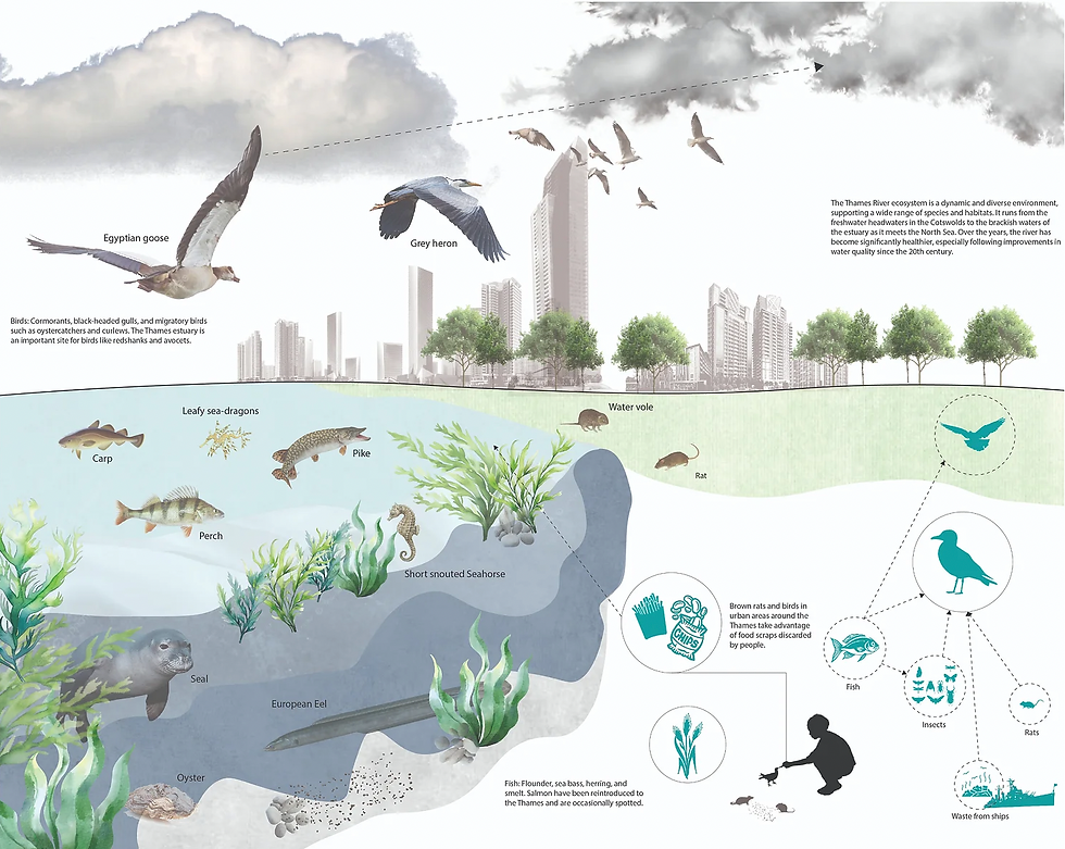
Fish: Flounder, sea bass, herring, and smelt. Salmon have been reintroduced to the Thames and are occasionally spotted.
Birds: Cormorants, black-headed gulls, and migratory birds such as oystercatchers and curlews. The Thames estuary is an important site for birds like redshanks and avocets.
Invertebrates: Crustaceans such as shore crabs, along with mussels and worms.
Mammals: Seals (harbor and grey seals), which are often seen around the Thames Estuary. Dolphins and porpoises occasionally venture into the river.
Vegetation: Salt-tolerant species like sea aster and saltmarsh grasses grow in the estuarine region.
Estuary (Lower Thames)
Location: The Thames Estuary, where the river meets the North Sea.
Habitat: A complex mix of tidal mudflats, saltmarshes, and sandbanks.
Species:
Fish: Estuarine species such as bass, plaice, and cod.
Birds: Thousands of wintering and migratory birds, including brent geese, dunlin, and knot. The estuary is a crucial resting and feeding ground for wading birds.
Invertebrates: The mudflats teem with worms, mollusks, and crustaceans that provide food for fish and birds.
Mammals: The estuary supports large numbers of seals and is occasionally visited by cetaceans like dolphins.

PLANT SPECIES
1. Achillea millefolium (Common Yarrow) - A member of the aster or composite family (Asteraceae), yarrow has flat-topped or dome-shaped clusters of small white flowers that bloom from April to October. An attractive, hardy perennial, yarrow can reach about 3 feet in height. Its aromatic, fine, feathery-cut leaves give the plant a soft, fern-like appearance.
2. Quercus robur (English Oak) - A large, deciduous tree growing up to 20–40m tall. Also known as common oak, this species grows and matures to form a broad and spreading crown with sturdy branches beneath. Look out for: its distinctive round-lobed leaves with short leaf stalks (petioles). Identified in winter by: rounded buds in clusters.
3. Corylus avellana (Common Hazel) - Hazel has shiny, brown bark and almost circular, toothed leaves with soft hairs on their undersides. It displays long, yellow catkins in spring, and provides a crop of hazelnuts in late summer.
4. Hydrangea macrophylla (Bigleaf Hydrangea) - Bigleaf hydrangeas grow into a rounded, mounding form, creating a bushy appearance. They have a relatively fast growth rate and typically reach a size of 2 to 6 feet (60-180 cm) in height and width, depending on the cultivar and growing conditions.
5. Fraxinus exelsior (European Oak) - The tree is easily identified in winter by its smooth twigs that have distinctive black, velvety leaf buds arranged opposite each other. Look out for: the black buds and clusters of seeds which are key features. Identified in winter by: its distinctive black buds and flattened twigs.
6. Crataegus monogyna (Common Hawthorn) - Its flowers are usually white, but occasionally pink. Leaves turn yellow and orange before falling in autumn. The dense foliage makes a great shelter for many bird species. Hawthorn has long been used as a hedging plant.
7. Hedera helix (English Ivy) - Dark green and glossy with pale veins. Juvenile leaves have 3-5 lobes and a pale underside. Mature leaves are oval or heart-shaped without lobes. Common ivy (shown right) has leaves with 3-5 lobes, while Atlantic ivy has leaves with 5-7 lobes.
8. Sambucus nigra (Elderberry) - Elderberry has creamy-coloured, highly scented flowers. Its leaves are pinnate with 5–7 oval leaflets. Mature trees can grow to around 15m in height. It produces small, purple-black berries which are sour to the taste.
9. Acer pseudoplatanus (Sycamore) - The sycamore is a tall, domed tree of the maple family. Its five-lobed leaves have toothed margins and characteristic red stalks. Its flowers are small, green and hang in spikes, turning to distinctive winged fruits, known as ‘samaras’.

The geological foundation of London plays a key role in shaping its terrain and the development of the city.
A. London Basin
London is situated in the London Basin, a geological structure bounded by chalk hills to the north (the Chiltern Hills) and the south (the North Downs). This basin is filled with younger sediments like sands, gravels, and clays. Chalk Beds: The chalk forms the highlands to the north and south, but it is not visible in central London, where the terrain is dominated by clay and river deposits.
B. Clay and Gravel Layers
Much of London is built on a layer of London Clay, a thick, impermeable clay that influences the city’s drainage and water retention. Overlying this clay are more recent deposits of sand and gravel, particularly in areas close to the Thames. Gravel Terraces: The Thames and its tributaries have deposited gravel terraces, particularly in west London, which have been important for the city’s building foundations and transport routes.
PHYTOVOLATILIZATION
Phytovolatilization involves the uptake of contaminants by plant roots and its conversion to a gaseous state, and release into the atmosphere. Plants extract volatile metals from the soil and volatize them from the foliage. Example: Mercury and selenium can be removed in this way. Less research has been conducted in the areas of phytostabilization and phytovolatilization than on other methods.
PHYTODEGRADATION
Phytodegradation involves the degradation of organic contaminants directly, through the release of enzymes from roots, or through metabolic activities within plant tissues. In phytodegradation organic contaminants are taken up by roots and metabolized in plant tissues to less toxic substances. The plants absorb hydrocarbons and other complex organic molecules, then metabolize or mineralize them in chemical reactions energized by sunlight. Example: Some enzymes break down ammunition wastes (explosives), chlorinated solvents or herbicides.
PHYTOEXTRACTION
The use of plants to remove contaminants from the environment and concentrate them in above-ground plant tissue is known as phytoextraction. Some heavy metals such as copper and zinc are removed from the soil by moving up into the plant roots. Phytoextraction (or phytoaccumulation or phytosequestration) exploits the ability of plants or algae to remove contaminants from soil or water into harvestable plant biomass.
RHIZOFILTRATION
Rhizofiltration is a form of phytoremediation that involves filtering contaminated groundwater, surface water, and wastewater through a mass of roots to remove toxic substances or excess nutrients. Both absorption and adsorption of the contaminants on the root takes place during the process. The major difference between rhizofiltration and phytoextraction is that rhizofiltration is used for treatment in aquatic environments, while phytoextraction deals with soil remediation.
PHYTOSTABILIZATION
Phytostabilization involves the establishment of a plant cover on the surface of the contaminated sites with the aim of reducing the mobility of contaminants within the vadose zone through accumulation by roots or immobilization within the rhizosphere, thereby reducing off-site contamination.
SOLUTIONS
Enhancing woodland within urban areas creates a happier more biodiverse environment for the public and has the chance to increase numbers of green corridors.
Benefits:
Biodiversity Boost
Carbon Sequestration and Climate Mitigation
Soil Health and Erosion Control
Improved Water Quality and Regulation
Recreation and Mental Health Benefits
Economic Opportunities
Enhancing woodland areas brings substantial environmental, economic, and social benefits, especially in terms of biodiversity, carbon storage, and recreation. However, it requires careful planning and management to avoid drawbacks like high costs, invasive species, wildfire risk, and resource conflicts. Thoughtful, well-planned woodland enhancement can maximise benefits while minimising negative impacts, making it a valuable tool for sustainable land management and climate resilience.
Cycle and footpaths promote healthier lifestyles for the public and a lower carbon footprint in the area.
Benefits:
Health and Wellness
Environmental Impact
Traffic Reduction and Safety
Economic Benefits
Social Cohesion and Community Interaction
Tourism and Recreation
Cycle and footpaths offer extensive benefits for public health, environmental sustainability, and community engagement, and they provide alternatives to motorised transport, improving urban liveability. However, they require careful planning and investment to address potential environmental impacts, safety concerns, and the challenges of ongoing maintenance and weather dependency. When designed with these factors in mind, paths can maximise benefits and foster healthier, more connected communities.
Sustainable urban drainage is good for enhancing urban resilience, protect water resources, promote biodiversity, and improve community well-being, making them an effective strategy for sustainable urban development.
Benefits:
Flood Risk ReductionEnvironmental Impact
Improved Water Quality
Groundwater Recharge
Enhanced Biodiversity and Habitat Creation
Reduction of Urban Heat Island Effect
Improved Urban Aesthetics and Recreational Spaces
Cost Efficiency and Resilience
Health and Well-being Benefits
Educational Opportunities and Community Engagement
KEY FINDINGS
Green and Blue Infrastructure:
Blue infrastructure in London (The Thames) is vital for transport connections, recreation, and biodiversity. It connects many green spaces and serves as a natural flood defence.
London contains a wide range of green streets, green roofs, and programs like the London Urban Forest Plan. These spaces contribute to air quality, mental health, and offer habitats for wildlife.
When looking into how to improve green infrastructure, in areas which are built up, it is best to incorporate these practices into the buildings themselves instead of recreating the areas format. For example, a good way to bring more nature into a site is to use green roofs which are just used as an addition to a build as this is cost efficient and, if done correctly, will not need much upkeep or interference as it is a natural process once it has been there for a long time.
Ecology:
London is home to a wide variety of bird species due to its diverse habitats including parks, rivers, gardens, and wetlands. With the high number of bird species it would be good to facilitate to their needs and evaluate their natural habitats.
There is a large collection of different animals within the Thames making it a vital habitat for each species.
Highly important when considering natural factors to ensure the protection of the land.
Ecology is an important factor to consider during the design process as it is the form of the land and the interaction of nature within its formed environment. Its how everything e.g. the buildings, the trees, and the animals all come together to form a habitat.
Conclusion:
The depth of research surrounding ecology is highly important when creating a proposal. The guidelines must consider the existing ecological factors and biodiversity in order to not hinder the development of an environment. Looking at different improvements could introduce new species of animals or help them with migration through green corridor bridges or the implementation of other structures. The relationship between humans and habitats is also important as it can lead to a harmony that benefits the entire city if used correctly.
SWOT
Strength: the biodiversity in the thames is successful in a way which introduces new species to the site and London
Weakness: when the area was developed there was clearly no understanding of the affects it would have to different ecosystems
Opportunity: incorporating changes towards different types of species could help maintain environments by using sustainable methods such as green corridors
Threat: with the growing population of people this brings an unbalanced food chain due to waste products and mass amounts of transport connections needed
Lesson Notes
27.09.24
Term 1: Strategy, on the waterfront
Term 2: Zoom in and take a piece of the site
Assessed using the following criteria:
Designing on a different scale
Human interaction
Biodiversity
Thames clippers and Visit Greenwich – looking for ways to promote Greenwich, parts which are under exploited, opportunities to develop their business (Thames clippers), connectivity, transport links, clipper boats – is there a slower option, continuity along the path of the river, development policy
Submissions:
Portfolio – Final
A3 Site analysis
Urban development and ecological edge
Cross collaboration
Site history
Surface geology
Ecology
Green and blue infrastructure
Politics and communities
Technology and sensory data
Transportation
Connectivity
Think about non-humans
Spring tide and neep tide linked to the phase of the moon
Look at the tidal range, spring, and autumn equinox – low and high tide
Mud-larking
SUDs
Width of the path – quantitative and qualitative decisions
1:2500 @A0 research drawings
Manifesto/vision poster
1:2500 @A0 proposal drawings
Digital scenes
Process blog
04/10/24
Report Brief:
Introduction
Overview of the project scope
Cultural heritage
Why this project matters
Site History
Historical evolution
Cultural heritage
Maritime legacy
Specific topics
Site analysis and environmental factors– detailed understanding of the site
Sun and shade
Wind and microclimate analysis
Water flow and drainage
Divide the site into areas of connectivity and those without
Technology and sensory data
Lidar, 3D scans
Sensory mapping
Ecology and green infrastructure
Ecological survey
Green corridors
Proposed ecological solutions
Connectivity and accessibility
Existing transport networks
Opportunities for improved access
Role of piers and jetties
Materials, land use, and zoning
Existing land use and zoning
Sustainable materials
Adaptive reuse opportunities
Opportunities and constraints
SWOT analysis Strength, weakness, opportunity, threats
Key design challenges
Strategic opportunities
Mapping
Comprehensive mapping
Evaluation of elements
Conclusion
Proposed zoning and strategy – conclusion (group)
Zoning plan
Ecological and connectivity corridors
Public realm and transport strategy
Design guidelines
Set of rules used to design masterplan
24/10/24
Key Findings
Ecology
Biodiversity
Green Cover
Blue Cover
Green Infrastructure
25/10/24
Green corridor design guidelines:
Connectivity
Ecological Integration
Public Space and Amenities
Habitat Connectivity
Shade and Microclimate
Resilience and Maintenance
1/11/24
Feedback:
Less double page spreads
Reasons for doing images
Importance of doing things
Why is it relevant
Key bullet points on cards when presenting
Seeing the uses of the site in action
Critically engage with AI
What is the problem we are trying to solve – justifying
Start to pose questions as to what to start next – opening a discussion for the next stage
Biodiversity – qualitative evidence, local biodiversity action plan, particular set of species, evidence-based approach
Importance of areas mapping
Go into more detail and depth
Windows of potential experience – why is this useful
More mapping
Green corridors – issues, the lack, tell a story
What we are going to go through
Qualitative data – spatial
Visualise the disconnect
More engagement with the river
The effects the boats are having on the banks


Comments